The past two "trips" I've taken have been a combination of a wonderful ride, and a glorious destination. It seems like the best of both worlds to enjoy not only the roads, but what's at the end of the road. So with that in mind, here's the latest trip. One that left me both exhilarated and exhausted.

Destination Highways says this about Hwy 20, the North Cascades Highway. It is their number 1 rated road in Washington State.
- Quote :
- It’s said there are only three kinds of motorcyclists: those who’ve been down... those who are going down... and those who are going down again. Here in Washington, there are actually three more: those who haven’t been down DH1, those who plan on going down DH1, and those for whom the top ranking of this spectacular ride comes as no surprise.
I thought about that comment as I debated on where to go on Saturday. It looked like perhaps the last opportunity to go somewhere, and I didn't want to let it go to waste. Places in the North Cascades National Park have been compared with the best the Swiss Alps has to offer...and come out on top. So I decided to combine the trip with perhaps a short hike before heading back. Little did I know...
I left just a little after dawn. I had in mind endless streams of traffic heading out of town for the Labor Day weekend, and I didn't want to get stuck in the traffic. At Lake Stevens, I picked up Hwy 9 and headed north. There was still a fog in the low areas, making some beautiful soft scenes, but the places where those picturesque sights were also on main roads with place to pull over safely. As I rode, straight roads gave way to gentle sweepers and country side. I picked up Hwy 530 and rode through Arlington Heights. I should've taken a picture because it would help my "
Rounderdom" creds, because I saw a sign at a church there that read 40F! I should've checked the temp on the bike, but my glove liners inside my summer weight gloves and the sweatshirt I had decided to wear were telling me the temperature might've been pretty close.
From then on, the road just opens up. Sweepers, gentle turns, hard 90 degree corners in the middle of tiny little towns to get you to slow down longer than the blink of an eye. Towns with a much slower, and enviable, pace of life than the Seattle area has. Cows and horses grazing in the fields. And mountains rising up alongside.

While that picture looks good with the mountains in the distance, I took this picture from across the road.

At Rockport, I joined up with Hwy 20, the North Cascades Highway. This road is a delight, with mountains rising up even higher, and one corner after another.


Diablo and Ross lakes are part of the Skagit River Hydroelectric Project. The road crosses over Diablo Lake at this point.

Just afterwards, the road climbs about 700 feet to this lookout.

There are times you see the signs warning you of rocks on the road. There was no sign, but this was a wake-up call!

The rocks you see on the road are about 50 feet in front of me. Most are about the size of half a loaf of bread. The one off the right mirror...that's about 3 feet across and 2 feet tall! Now where did that come from???

...maybe up there somewhere?
After 3 hours of riding, I reached the trail head parking lot for Maple Pass Loop. It is 7.5 miles long with over 2000 feet of elevation gain. As I started up the trail, I came across these two signs. Hmmm...


The hike up goes through several life zones, starting in old growth timber, then breaking out into alpine meadows and then mountain ridge lines. Here is the first glimpse of the beginning of the alpine meadows.

Shortly after, I got my first glimpse of Lake Ann (...where the bears were). I stopped to get some water and a snack, and put on the bug juice and sun screen while just trying to soak it all in.

I didn't know it at the time, but the trail leads up along the upper ridge and up that small peak in the upper left.
I stopped here for a short break and to take in the views.

If you look closely, you can see a teal green lake in the middle.

At one of the many stops I was making along the way, I looked down to Lake Ann and this view.

Almost up to the top of the ridge line, Lake Ann is down to the left.

There are a couple pictures of Early Winters Spires. Here is one at the park boundary.

It is a little hard to get the perspective. There's a lot of distance between me and the spires ahead. You can get a little feel of it by looking at the size of the trees. In the foreground, they are small. In the slopes below the mountain...they are almost just tiny bits of dark green.

I stopped to eat lunch on the rock in the foreground.

It is hard to get a feel in 2D for what you see in 3D. You're on top of the world it seems.

The zoom gives a little feel for the massiveness of what is out here. The first is Glacier Peak. I'm not sure what the second is.


Down below, is my first view of Rainy Lake. The trail stops somewhere down there, easily a thousand feet below.

The views were just so outstanding, it was hard to keep from taking pictures. It is too good, not to share.

Here is Lake Ann off on the left as I headed down.

Rainy Lake, a little closer now.

As I got a little farther down this trail, I looked to the left and saw Lake Ann way down below. I looked to the right and saw Rainy Lake. And it was a straight drop down. If you slipped here, there was nothing to do but bring in a body bag. I didn't take pictures to try capturing "the moment".

There is a reason for this picture that isn't readily apparent. Do you see the hikers up on the ridgeline at the other park boundary sign?

Here's a little closer look with the zoom...

When I finally got all the way down, I couldn't resist walking another mile to the separate trail to Rainy Lake. That tiny spec in the distance was a lot bigger down below.

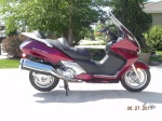
Back at the parking lot. Deborah, my 2008 Burgman 400, never looked so good to tired feet!

The ride home was uneventful, except for the sun in my eyes for much of the trip. I didn't make any stops going home. A range of 200+ miles is nice to have on trips like this.
There are larger pictures and some others not included at http://burgmanusa.com/gallery/Daboo/MaplePass/
Chris